I-15/US-20 Connector Online Meeting
Welcome
Thank you for your participation in our I-15/US-20 Connector online meeting. We would like to share updates and receive your input on the project’s development. Your feedback is important for moving this project forward.
This online meeting has closed. While the official comment period has closed, you are welcome to contact the project team at I-15US20Corridor@itd.idaho.gov or submit a general comment through the project website.
How to navigate this meeting
Use the arrow on the right side of your screen to navigate forward through the presentation. An arrow to navigate backward will appear to the left as you progress.
Use the navigation bar at the left of the screen to revisit any part of the meeting.
Please provide feedback where indicated, or provide a comment at any time by clicking the “Comment” button at the top right of the screen.
Use the tabs throughout the meeting to view more information.
Project Overview
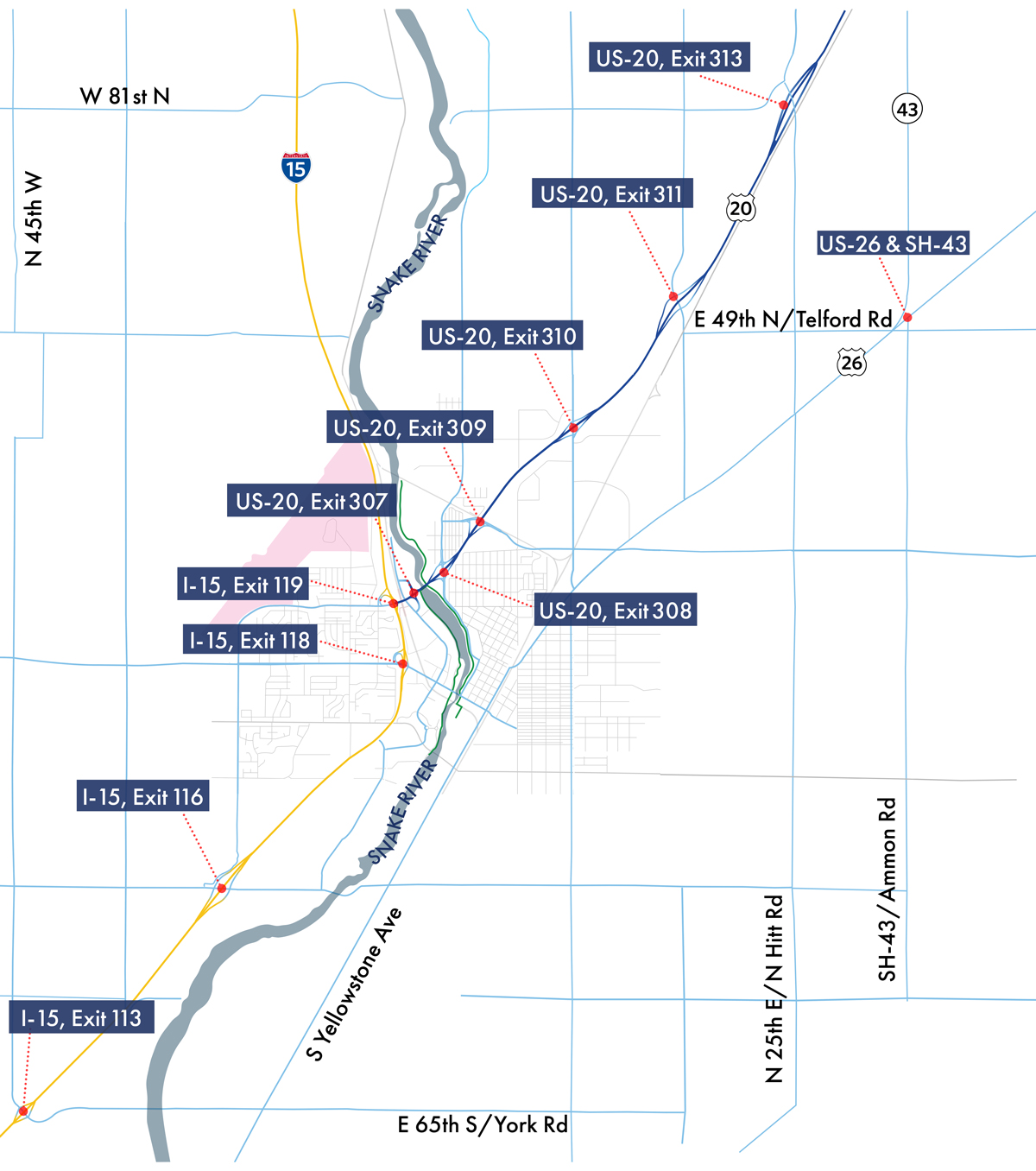
For the past three years, ITD has been working closely with the City of Idaho Falls and Bonneville County on a Planning and Environmental Linkages (PEL) study.
The PEL study is focused on developing a range of alternatives to address improvements to the I-15 and US-20 in or near Bonneville County and Idaho Falls.
To review the project purpose and needs, visit the study website. Opens in new window
For more on the PEL process, .
How We Got Here
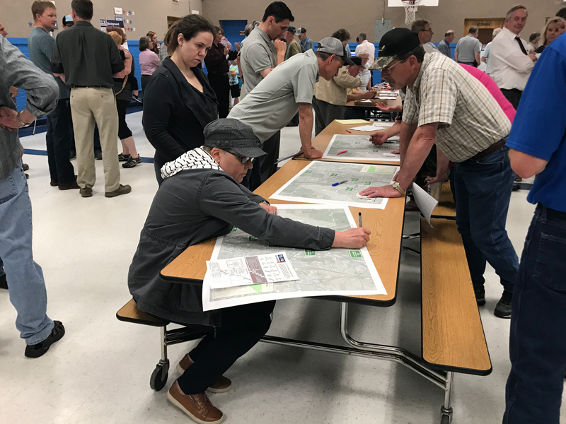
The project team has been actively engaging the public throughout the project development process to determine how the corridor can be improved to best serve Idaho Falls citizens and the growing region.
September, 2017
Project Start
May 9, 2018
Public Involvement Meeting #1: Community Kick-Off Meeting
 Meeting #1 Summary Opens in new window
Summer 2018
Concept Alternative Development and Level 1 Screening
Level 1: Resulted in 10 alternatives, including the no-build alternative, which were presented to the public at an open house meeting in September 2018.
Winter 2019 – Spring 2019
Concept Alternative Refinement and Level 2 Screening
Level 2: ITD presented alternatives to the public at a meeting held on May 16, 2019. There were 341 people in attendance and 194 comments were received.
Winter 2019 – Spring 2020
Concept Alternative Refinement and Level 3 Screening
Level 3: Screening occurred over the past few months which resulted in two recommended alternatives moving forward. Those alternatives are the focus of this online meeting.
Summer 2020
Public Involvement Meeting #4
We Are Here
Summer – Fall 2020
Prepare, Review with Agencies, and Publish PEL Report
2+ Year Process
NEPA Process
Alternatives Development
The project team developed and refined concept-level alternatives based on study criteria and public input. Each alternative is analyzed and screened to determine if it meets the Purpose and Need of the PEL.
The PEL report will be completed by Fall 2020 and recommended alternatives, along with the no build alternative, will move into the National Environmental Policy Act (NEPA) process.
Activate image to enlarge in a new tab.

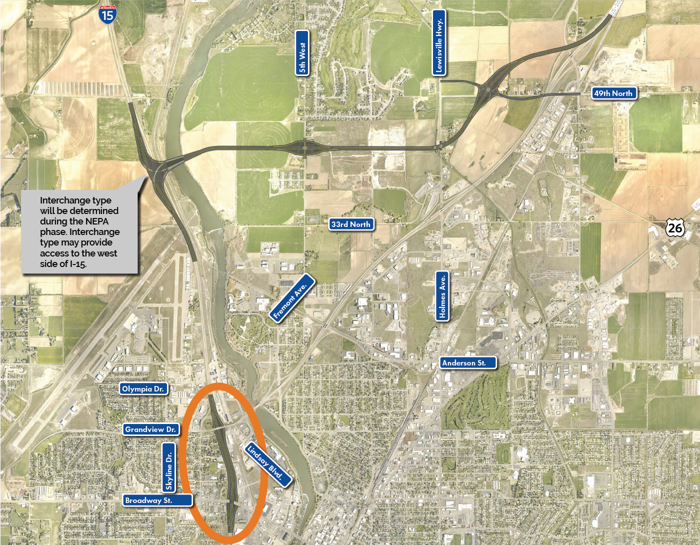
Alternative C3
Alternative C3 — Removed From Consideration
- Features
- Benefits
- Challenges
- Provides direct ramp connections from I-15 south of Exit 118 to US-20
- Adds a new crossing to the north at Higham Street for local street connectivity
- Provides opportunities to develop pedestrian and bicycle connections between I-15 and US-20
- Separates the local and through traffic between Exit 118 through the City Center/Riverside Exit 308A
Activate image to enlarge
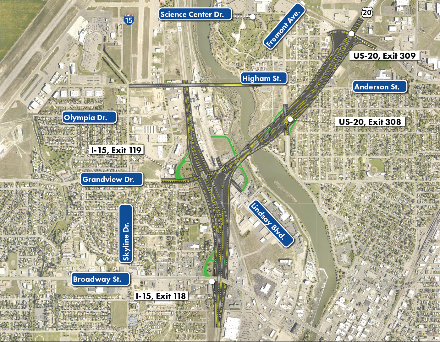
Map Legend
RoadwayStructureRoadway Obliteration
The exact impacts of the alternatives to residences, businesses, access, etc., are unknown. Impacts will be determined as design details are refined.
Alternative E3
Alternative E3 — Recommended For Consideration
- Features
- Benefits
- Challenges
- The I-15 Broadway Interchange Exit 118 and New I-15/US-20 Olympia Drive exit are farther apart and connected with direct access ramps
- US-20 is realigned to the north
- The new I-15/US-20 Olympia Drive exit is north of the existing Exit 119 at Grandview
- Converts current US-20 between Grandview Drive and Fremont Avenue to a local street
- The Alternative E3 US-20 location results in a shorter new Snake River bridge crossing
- Moves regional traffic from I-15 through direct access ramps that lead to/from US-20
Activate image to enlarge
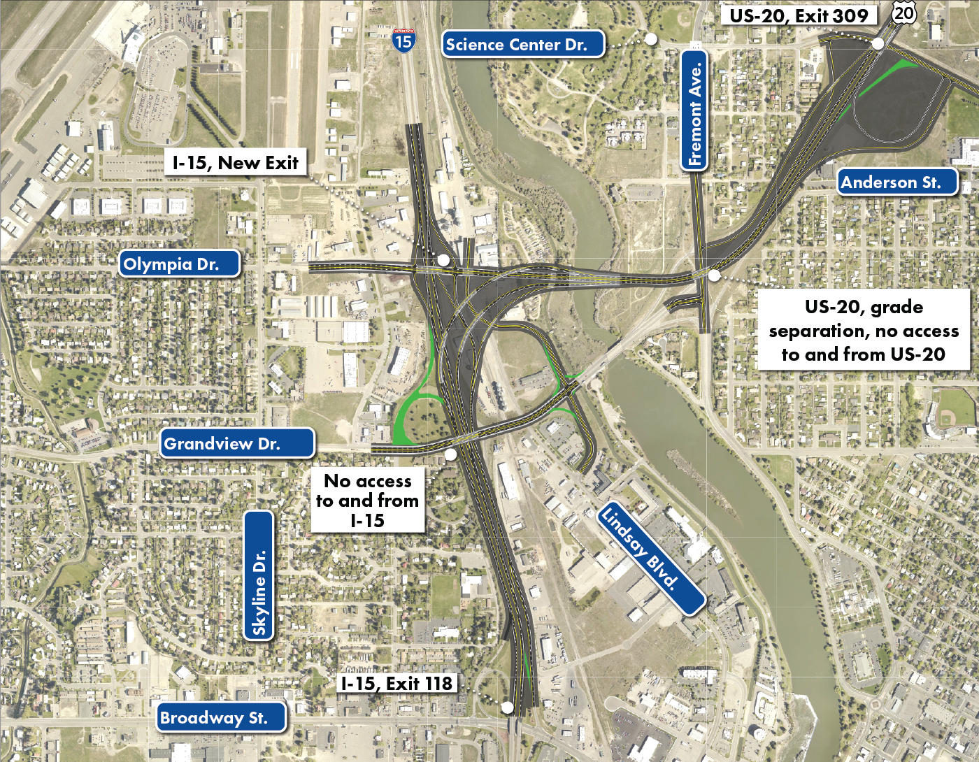
Map Legend
RoadwayStructureRoadway Obliteration
The exact impacts of the alternatives to residences, businesses, access, etc., are unknown. Impacts will be determined as design details are refined.
Alternative H2
Alternative H2 — Recommended For Consideration
- Features
- Benefits
- Challenges
- Moves the east/west portion of the new US-20 alignment farther south than previous Alternative H
- Converts current US-20 between Grandview Drive and the Lewisville Highway to a local street
- Realigns US-20 and connection to I-15 first, followed by a possible split-diamond interchange at Exits 118 and 119
Activate image to enlarge
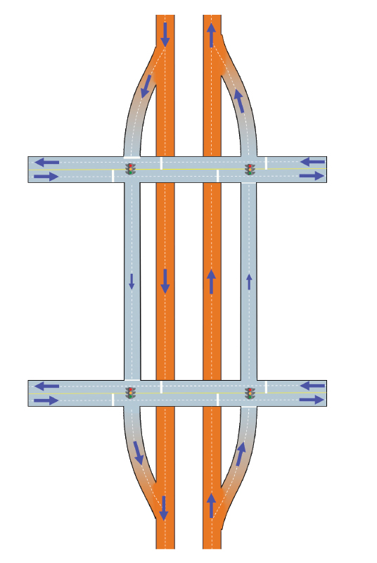
Split-Diamond Interchange
The split-diamond interchange is a potential option to address the existing conditions. More analysis will need to be performed during the NEPA process to develop options on I-15 between Exits 118 and 119.
Map Legend
RoadwayStructure
The exact impacts of the alternatives to residences, businesses, access, etc., are unknown. Impacts will be determined as design details are refined.